
Maps of America during the pre-Columbus era are scarce as America was largely unknown and unexplored, except by the natives who lived there.
Click on maps to link to source and zoom in on details.
Discovery of North America
Shows routes of principle voyages to the New World between 985 and 1791. Three of these predate Colmbus.
Click on map to go to source, then click again to enlarge so that labeling can be read clearly
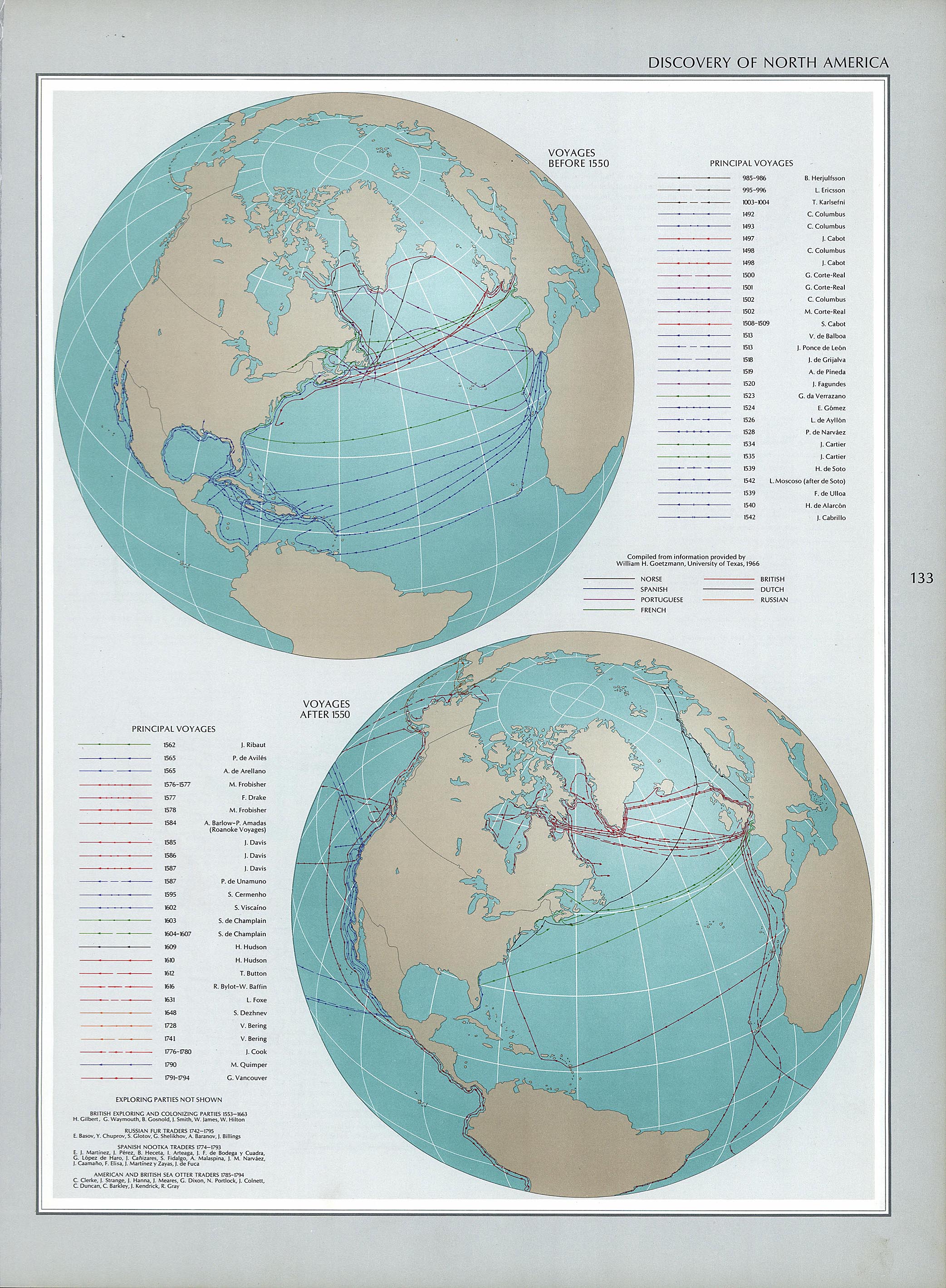
Source: Source: National Atlas of the United States 1970. Available from Perry-Castañeda Library Map Collection - University of Texas
Paleo Period, Changes Over Time: 10,000 BCto 1200 AD
The nomadic lifestyle prevails everywhere, humans subsisted by hunting (of larger animals, including mammoth), gathering, and fishing. There is no evidence of permanent habitations or of agriculture.
Click on map to go to source, then drag time line to see changes over time.

Source: Mapping History, website created with funds provided by the University Of Oregon.
____________________________________________________________________________________________________________________
Native North Americans on the Eve of European Contact - Cultural Areas - 1500 AD
Scholars refer to the various Native American cultural groups by using the labels noted here.
Click on map to go to source, then click on each factor.

Map below compares these four factors: language, sustenance patterns, clothing, and population density.

Source: Mapping History, website created with funds provided by the University Of Oregon._____________________________________________________________________________________________________________
Early Indian Tribes, Culture Areas, and Linguistic Stocks - Eastern U.S. dates not specified.

Source: Sturtevant, William C, and U.S Geological Survey. National atlas. Indian tribes, cultures & languages: United States. Reston, Va.: Provided by Library of Congress.Map Collection
Vinland Map of the world, circa 1434, depicts a potion of North America explored by Leif Eriksson. See detail on smaller map below.

Source: Beinecke Rare Book & Manuscript Library, Yale University, https://brbl-dl.library.yale.edu/vufind/Record/3520245
Close-up of area representing North America.
 |
The Vinland Map of America was found in a Geneva bookshop i 1957. It depicts a land (known as Newfoundland today) explored by Leif Eriksson in the 11th century.that he called Vinland. It is the earliest map of North America. Its authenticity was immediately called into question but more recent testing seems to prove its age.dates to around 1434. Yale alum, Paul Mellon, bought the map in 1959 and promised to give it to Yale University if they could authenticate it. After 7 years of testing, results were published by three scholars who were convinced it was real. Questions still remain, however.
Photo of actual map.- read more about it here: Cumings, Mike. Yale putting high-tech tests to its controversial Vinland Map. Yale News, Feb. 28, 2018. Brandeis University. The Vinland Map: Explore the Evidence, |
This map by Henricus Martellus may have guided Columbus. It is undated but is thought to have been published in 1491. America was unknown at the time, so the map depicts Asia, Africa, and Europe. When Columbus landed in the Bahamas, he thought he was instead near Japan, which coincides with Japan's location on the map. Though badly faded, new techniques made it possible to read hundreds of place names. The original map is 6ft x 4ft.
Quill, Elizabeth. Did This Map Guide Columbus?: Researchers decipher a mystifying 15th-century document. Smithsonian Magazine, June 2015,
https://www.smithsonianmag.com/history/did-this-map-guide-columbus-180955295/
Click on the map to use interactive features that allow you to read some of the hidden text. You may also enlarge map to full screen.


