
After Columbus landed in the New World, other explorers followed. The Spaniards were among the first Europeans to explore and settle in what would become the United States. However, England became the dominant presence along the Atlantic coast, establishing the first colony in Jamestown Virginia in 1607. This era lasted until 1775 when the War of Independence began..Also see Discovery of North America map in pre-Columbus maps.
Click on maps to link to source and zoom in on details.
Development of North America, 1492–1564
A map of the Americas showing the European exploration and development between the first voyage of Christopher Columbus (1492) and the establishment of Saint Augustine, Florida in 1564. The map is color–coded to show the territories claimed by Spain, and territory claimed by France in the Carolinas and northern Florida in 1562. The areas in North America explored by the Portuguese and British in this period are shown, with the name of the explorer and date given.
Click on map for more details.

Source: Source: Albert Bushnell Hart, LL.D., The American Nation Vol 3 (New York, NY: Harper and Brothers, 1906) 135
Map Credit: Courtesy the private collection of Roy Winkelman, Available from Maps ETC, Florida Center for Instructional Technology (FCIT) at USF.
_________________________________________________________________________________________________________________
Early Explorers of the Atlantic Coast, 1492-1620

Source: Robert H. Labberton, New Historical Atlas and General History (New York, NY: Townsend MacCoun, 1886) Plate LIX
Map Credit: Courtesy the private collection of Roy Winkelman. Available from Maps ETC Florida Center for Instructional Technology (FCIT) at USF.
____________________________________________________________________________________________________________________
"America Septentionalist Pars. from the West-Indische Paskaert", featured in E.B. O'Callaghan's "Documents Relative to the Colonial History of the State of New York" (1856-1857). Lithograph reprint of a 1621 map by Anthony Jacobsz.

Source: Wikimedia Commons
Roanoke Island, Jamestown, and St. Mary's, 1584–1632
A map of the Chesapeake Bay and Pamlico Sound area showing the initial Virginia Colony established by Sir Walter Raleigh and Queen Elizabeth I in 1584 through the European settlements established by 1634, including Roanoke Island, Jamestown (1607), and St. Mary's, Maryland (1632). The map is color–coded to show the coastal areas granted in 1609, and the areas settled by 1632.

Source: Albert Bushnell Hart, LL.D., The American Nation Vol 4 (New York, NY: Harper and Brothers, 1906) 34
Map Credit: Courtesy the private collection of Roy Winkelman. Available from Maps ETC.
___________________________________________________________________________________________________________________
The British Colonies in North America 1763 - 1775
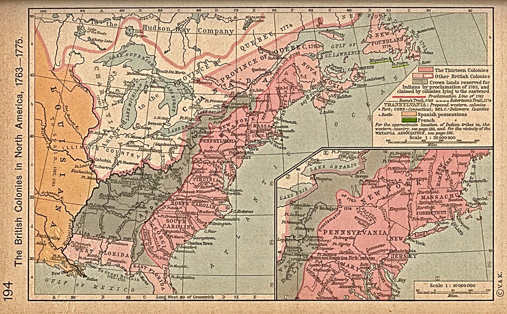
Source: From The Historical Atlas by William R. Shepherd, 1923. Available through the Perry-Castañeda Library Map Collection
____________________________________________________________________________________________________________________
Middle British Colonies of America, 1771
Virginia, Maryland, Delaware, Pensilvania, New-Jersey, New York, Connecticut & Rhode-Island:

Source: Repository - Library of Congress Geography and Map Division Washington. Available from Library of Congress Map Collection
__________________________________________________________________________________________________________________
Virginia, 1577
A facsimile of an early map (1651) showing the discoveries of Sir Francis Drake in North America, including the coastline of Ould Virginia and Maryland, the Bay of Checepiake (Chesapeake Bay), Lord Delaware Bay, Cape Hatteras and Cape Fear, and the Sea of China and the Indies (Pacific Ocean) just beyond the mountains of Virginia.

Source:Justin Winsor, Narrative and Critical History of America Vol. III (Boston, MA: Houghton, Mifflin and Company, 1884) 465
Map Credit: Courtesy the private collection of Roy Winkelman. Available from Maps ETC.
European Colonization in North America, 1500–1700
The map is color–coded to show the possessions of the British, French, Spanish, Dutch, Swedish, and Danish. The map shows the territory in dispute between the English and French at the time, and indicates the New Netherlands, including the Swedish Settlements on the Delaware which had been annexed by the Dutch in 1655, were ceded by the Dutch to England in 1664.
 Source: Ward, Prothero, and Leathes, The Cambridge Modern History Atlas (New York, NY: The Macmillan Company, 1912)
Map Credit: Courtesy the private collection of Roy Winkelman. Available through Maps ETC
____________________________________________________________________________________________________________________
Eastern North America 1650
Areas of North America claimed by England, France, and Spain, as well as unexplored areas.

Source: Nathaniel Wright Stephenson, An American History (Boston, MA: Ginn and Company, 1913) 77 Map Credit: Courtesy the private collection of Roy Winkelman . Available through Maps ETC
__________________________________________________________________________________________________________________
Dutch and Neighboring settlements, 1600s
A map of New Netherlands in the 1600's showing New Amsterdam and Dutch Fort (Albany) established in 1623, the English Settlements on the Connecticut River (Hartford) and the New Haven Colony, and the southern Dutch and Swedish settlements on the Delaware Bay and Delaware River.

Sources: Gertrude van Duyn Southworth, A First Book in American History (New York, NY: D. Appleton and Co. , 1907) 76
Map Credit: Courtesy the private collection of Roy Winkelman. Available through Maps ETC
___________________________________________________________________________________________________________________
North America in 1770

Source: Mapping History, website created with funds provided by the University Of Oregon.
